


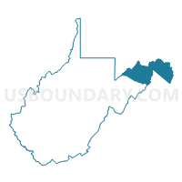
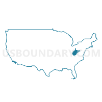
Berkeley, Jefferson, Mineral, Hampshire & Morgan Counties PUMA, West Virginia
About
Outline

Summary
| Unique Area Identifier | 194384 |
| Name | Berkeley, Jefferson, Mineral, Hampshire & Morgan Counties PUMA |
| State | West Virginia |
| Area (square miles) | 1,736.69 |
| Land Area (square miles) | 1,727.93 |
| Water Area (square miles) | 8.76 |
| % of Land Area | 99.50 |
| % of Water Area | 0.50 |
| Latitude of the Internal Point | 39.36993690 |
| Longtitude of the Internal Point | -78.44944200 |
Maps
Graphs
Select a template below for downloading or customizing gragh for Berkeley, Jefferson, Mineral, Hampshire & Morgan Counties PUMA, West Virginia


Neighbors
Neighoring Public Use Microdata Area (by Name) Neighboring Public Use Microdata Area on the Map
- Allegany & Garrett Counties--Cumberland City PUMA, MD
- Loudoun County (West & South)--Leesburg Town PUMA, VA
- Northern Shenandoah Valley Regional Commission (North) PUMA, VA
- Randolph, Upshur, Barbour, Lewis, Hardy, Grant, Pendleton & Tucker Counties PUMA, WV
- Washington County--Hagerstown City PUMA, MD
Top 10 Neighboring County (by Population) Neighboring County on the Map
- Loudoun County, VA (312,311)
- Washington County, MD (147,430)
- Berkeley County, WV (104,169)
- Frederick County, VA (78,305)
- Allegany County, MD (75,087)
- Jefferson County, WV (53,498)
- Garrett County, MD (30,097)
- Mineral County, WV (28,212)
- Hampshire County, WV (23,964)
- Morgan County, WV (17,541)
Top 10 Neighboring County Subdivision (by Population) Neighboring County Subdivision on the Map
- Blue Ridge district, Loudoun County, VA (30,989)
- Valley district, Berkeley County, WV (21,229)
- Shenandoah district, Berkeley County, WV (21,115)
- Tuscarora district, Berkeley County, WV (20,830)
- Potomac district, Berkeley County, WV (15,806)
- Adam Stephens district, Berkeley County, WV (14,224)
- Stonewall district, Frederick County, VA (13,101)
- Back Creek district, Frederick County, VA (13,015)
- Kabletown district, Jefferson County, WV (12,271)
- Gainesboro district, Frederick County, VA (11,760)
Top 10 Neighboring Place (by Population) Neighboring Place on the Map
- Martinsburg city, WV (17,227)
- Keyser city, WV (5,439)
- Charles Town city, WV (5,259)
- Ranson corporation, WV (4,440)
- Shannondale CDP, WV (3,358)
- Inwood CDP, WV (2,954)
- Westernport town, MD (1,888)
- Romney city, WV (1,848)
- Shepherdstown town, WV (1,734)
- Fort Ashby CDP, WV (1,380)
Top 10 Neighboring Unified School District (by Population) Neighboring Unified School District on the Map
- Loudoun County Public Schools, VA (312,311)
- Washington County Public Schools, MD (147,430)
- Berkeley County School District, WV (104,169)
- Frederick County Public Schools, VA (78,305)
- Allegany County Public Schools, MD (75,087)
- Jefferson County School District, WV (53,498)
- Garrett County Public Schools, MD (30,097)
- Mineral County School District, WV (28,212)
- Hampshire County School District, WV (23,964)
- Morgan County School District, WV (17,541)
Top 10 Neighboring State Legislative District Lower Chamber (by Population) Neighboring State Legislative District Lower Chamber on the Map
- State House District 33, VA (113,100)
- State House District 29, VA (88,049)
- State Legislative Subdistrict 3B, MD (54,040)
- State Legislative Subdistrict 2A, MD (44,505)
- State Legislative Subdistrict 2B, MD (44,013)
- State Legislative Subdistrict 1B, MD (40,379)
- State Legislative Subdistrict 1C, MD (39,335)
- State Legislative Subdistrict 1A, MD (39,216)
- State House District 56, WV (25,419)
- State House District 55, WV (25,147)
Top 10 Neighboring State Legislative District Upper Chamber (by Population) Neighboring State Legislative District Upper Chamber on the Map
- State Senate District 27, VA (227,068)
- State Senate District 16, WV (149,067)
- State Senate District 3, MD (147,548)
- State Senate District 2, MD (131,810)
- State Senate District 15, WV (122,121)
- State Senate District 14, WV (121,969)
- State Senate District 1, MD (118,930)
- State Senate Districts not defined (Washington County), MD (0)
Top 10 Neighboring 111th Congressional District (by Population) Neighboring 111th Congressional District on the Map
- Congressional District 10, VA (869,437)
- Congressional District 6, MD (738,943)
- Congressional District 2, WV (648,186)
- Congressional District 1, WV (615,991)
Top 10 Neighboring Census Tract (by Population) Neighboring Census Tract on the Map
- Census Tract 9720, Berkeley County, WV (11,756)
- Census Tract 9719, Berkeley County, WV (9,879)
- Census Tract 9712.01, Berkeley County, WV (9,837)
- Census Tract 9721.02, Berkeley County, WV (9,710)
- Census Tract 9714, Berkeley County, WV (8,890)
- Census Tract 9711.02, Berkeley County, WV (8,554)
- Census Tract 9713, Berkeley County, WV (8,363)
- Census Tract 101, Clarke County, VA (8,318)
- Census Tract 109, Washington County, MD (8,188)
- Census Tract 9718, Berkeley County, WV (8,175)
Top 10 Neighboring 5-Digit ZIP Code Tabulation Area (by Population) Neighboring 5-Digit ZIP Code Tabulation Area on the Map
- 21502, MD (44,400)
- 22602, VA (28,443)
- 25404, WV (19,551)
- 25414, WV (17,024)
- 20132, VA (15,900)
- 25401, WV (14,622)
- 25427, WV (14,322)
- 21550, MD (14,194)
- 22603, VA (13,910)
- 26726, WV (13,306)